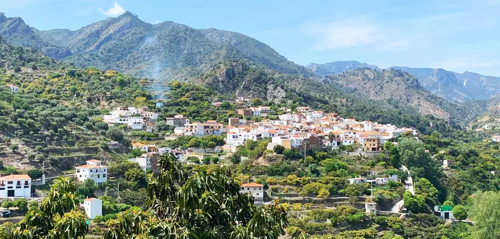
The Villages of Los Guájares
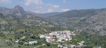
Just north, over the first wall of mountains that frame the Costa Tropical, is nestled the beautiful valley of Los Guájares. It is nourished by the River Toba that comes from the higher mountains and winds its way through the Los Guájares valley, providing abundant water for the lush fruit cultivation of the Guajar Valley.
The Los Guájares valley, long dominated by the Arab conquerors until the 15th century, was named Los Guájares by those Arabs which translates into "oasis between the mountains" and the village of Guajar Alto "paradise on earth".
There are three villages that comprise Los Guájares: Guajar Faragüit, Guajar Fondón, and Guajar Alto. The villages lie in the narrow Guajar valley winding among orange and chirimoya (custard apple) trees, old water deposits and beautiful ravines. These pristine mountain villages are home to about 2,000 people, supported by a thriving agricultural economy. The largest of the towns is Guajar Faragüit, the smallest is Guajar Fondón (Guajar Fondón is the lowest of the three towns, is surrounded by olive and almond trees, is watered by the Rio de la Toba, and is the closest to the N323 highway), and highest up into the mountains (and furthest from N323) is Guajar Alto. In the summer the River Toba is dammed up, in an idyllic spot within walking distance of the village, to create a small lake surrounded by a picnic area for residents and visitors in the Costa Tropical to enjoy.
Guajar Fondón: Guajar Fondón is located on the Rio de la Toba, at 263 meters of altitude, and it has almost 500 inhabitants. The church is an interesting example of the first Mudejar parish. It was restored in the second half of the XVIII century, respecting the original Mudejar architecture.
Guajar Faragüit: Guajar Faragüit is the most important of the three Guájares towns, since it houses the head of the district and the town council. Guajar Faragüit is located over Guajar Fondón and below Guájar Alto and its name means in the original Arabic "hidden garden". Near its center, crowning a hill, there is an old fortified town in a very good state of preservation called El Castillejo. It was built between the end of the XIII century and the beginning of the XIV century, during the period of Almohade domination.
Guajar Alto: As its name indicates, Guajar Alto is the highest of the three Guájares towns and it is situated at 450 meters in altitude. It is also the smallest of the three towns, and is the furthest away from the coast. The name Guájar derives from the Arab word "Wa-run" meaning "of difficult access".
Village Information
| Region: | Costa Tropical |
| Post Code: | 18615 |
| # of inhabitants: | ~ 2000 |
| Inhabitants: | Los Guájares |
| Distance to Granada: | 64 km |
Where is Los Guájares located?
Los Guájares of the Costa Tropical in the Granada province is a region of traditional small mountain villages located near the Mediterranean coast of Spain in the Andalucia (Andalus) region. Los Guájares is located in an area also called Valle de Guajar or Guajar Valley and is easily accessible by paved smaller roads that connect with a major highway.
Getting There
The nearest coast is at Salobreña. The large town of Motril is only 35 minutes from Guajar Alto, and the town of Almuñécar situated on the coast of the Costa Tropical is only a little further away.
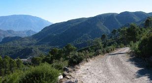
In addition to the highway access, there are more scenic options. Almuñécar is accessible via mountain roads, a stunning drive through winding mountain passes. If you take the old road to the coast from Pinos Del Valle (marked Motril), you will discover a spectacular route which winds across the hills, past picturesque ruins and high altitude vistas.
You will pass through the small hamlet of Zaza with its spring of mountain water for thirsty travelers and further along you will glimpse a dark red Arab fortress, which glows against the sky. It sits very prominently on a saddle of land with endless views down to Salobreña and the Mediterranean in one direction and across to the Alpujarras in another. On the other side of the road here is an old Italianate house, which was once a staging post for shepherds driving sheep and goats from the coast up to higher altitude summer pastures and making the seaward journey later in the year.
Save money on your next trip with our favorite travel websites!
| Find the Cheapest Hotels: | |
| The Largest Selection of Villas & Apartments: | |
| Cheapest, Most Reliable Car Rentals: | |
| Best Bus & Train Fares: | |
| Huge Selection of the BEST Tours & Activities | |
| Discount Tickets to Museums & Attractions | |